|
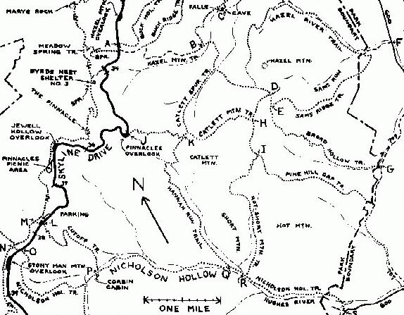
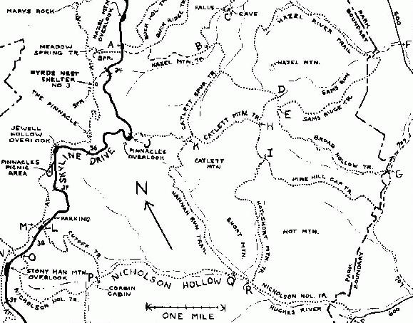
HIKE: Corbin Cabin. Round trip 2.9 miles; total climb about 1,095 feet; time
required 3:10. See map above; your route is L-P-L. The upper half of the
trail is somewhat rough and rather steep; the lower half is easy.
Except at the beginning, the trail follows a path built by the mountain
people. At first it descends along a ridge crest through mountain laurels and
young forest. Half a mile from the start, it swings left and descends the side of
a ridge for about 200 yards, then turns right beside a dry stream bed. About
0.4 mile farther on, as the trail makes another turn to the right, look for a stone
wall on the right, at a mountaineer homesite. The ruined cabin, 25 yards
downhill on the left, was the home of John R. Nicholson.
The cabin had a single room about 12 by 18 feet, with a loft, a lean-to, and a
covered patio. The chimney is still in good condition, and three walls are
standing. The cabin was built of logs of various diameters, not very skillfully
trimmed. The cracks were chinked with mud, and at least a part of the outside
was covered with vertical clapboard. Inside, the mud was concealed in places
by slats nailed to the logs. Some parts of the inside walls were covered with
heavy asbestos paper; other parts still show evidence of whitewash, or
peeling white paint. A round hole on the inside of the chimney shows that the
cabin had a stove as well as a fireplace. On the outside, an inverted "V" of
caulking on the chimney shows where the roof crest was. A small pool in the
stream, fifty feet beyond the chimney, was a reliable water source.
When the hollow was inhabited by the Nicholson family this cabin was near
one corner of a large clearing—nearly half a square mile in area—extending
to Corbin Cabin and well beyond it, and from there nearly a mile downstream
on both sides of the Hughes River, serving as garden space, cornfields, and
pasture.
Continuing on the trail, it's another 0.3 mile to Corbin Cabin. This stretch is
rich in evidence of the former inhabitants. There are ruins of several small
farm buildings, a few strands of barbed wire, old grape vines, and piles and
walls of rock: a byproduct of the struggle to create a workable garden plot—to
expose enough soil in one place for a patch of corn. The trail descends to cross
a small stream. About 250 yards beyond it is an old cemetery, a short distance
to the right of the trail. It's not easy to find; the graves are marked only by
uninscribed fieldstones.
Fifty yards before you reach a second stream, and fifty yards to the right of
the trail, is another ruined cabin. This one was relatively fancy, with tongue-
and-groove flooring, a stairway rather than a ladder to the loft, and a metal
roof. This was the home of John T. Nicholson.
After you cross the second stream, Hughes River, walk a hundred feet to
the junction with the Nicholson Hollow trail, at point "P" on the map. To your
left, it's 4.0 miles downhill to the Weakley Hollow fire road; to your right it's
1.8 miles uphill to Skyline Drive at Mile 38.4. Directly ahead is the locked
Corbin Cabin. If it's occupied, please keep your distance. If you'd like to rent it
for your own use, write to the Potomac Appalachian Trail Club, 118 Park Street, S.E., Vienna, VA,
22180-4609.
Corbin Cabin was built by George Corbin, an in-law of the Nicholsons, in
1909 when he was 21. According to Mr. Corbin's own account he borrowed
$500 to remodel the cabin and put on a tin roof, shortly before it was
condemned in 1936 and taken over by the Park. George Corbin received $500
for the whole property—land, cabin, and new tin roof. Members of P.A.T.C.
repaired and enlarged the cabin in 1953-54, and have since been responsible
for its maintenance.
About twenty families, most of them Nicholsons, lived in Nicholson Hollow
between Corbin Cabin and the present Park boundary. All the land that was
reasonably flat was cleared for gardens, cornfields, potato patches, pastures,
and orchards. There was a school about two miles downstream from Corbin
Cabin, near the mouth of Hannah Run. In early days the school also served as
a church, and a preacher came from Sperryville once a month. Later the
Hughes River Church was built near the schoolhouse and Warren Corbin, a
brother of George, served as preacher. A doctor came to the hollow from
Criglersville when he was needed.
George Freeman Pollock, founder and owner of the Skyland resort before it
became part of the Park, has unkind things to say about the Nicholson family
in his book Skyland. According to Pollock the Nicholsons called this valley
"Freestate Hollow", and considered it independent of the state of Virginia and
not subject to its laws or taxes. Aaron Nicholson, patriarch of the family, was
the king of Freestate Hollow, Aaron claimed to own all the land as far as the
eye could see, because he had walked around it. The Nicholsons were in fact
squatters, who owned nothing. So says Pollock.
|
Ed.: Pollock was known for his "tall stories," and
this is one of them. According to Reed Engle,
Historian of Shenandoah National Park, and Audrey
Horning, Archaeologist from the Colonial
Williamsburg Foundation, this image of the lawless
Nicholsons was created by Pollock and accepted until
recent scholarly research has shown that the average
landholding for members of the Nicholson family
averaged 100 acres in the 19th century and of that
acreage 25 was cultivated. In 1932, property records
indicate that no residents of Nicholson Hollow were
squatters and only a handful were renters.
(ajh, 12/00).
|
Aaron Nicholson lived in a two-story house about 0.2 mile
downstream from Corbin Cabin. In winter, when the leaves are down, you can
see the ruined house from the trail. In summer you have to leave the trail,
cross the stream, and look for it.
|
|
HIKE: Corbin Cabin. Circuit 4.3 miles; total climb about 1,350 feet; time
required 4:20. A medium-difficult hike; part of the trail is rough. See map,
page 134; your route is L-P-O-N-M-L.
As above, to Corbin Cabin. At the trail junction, as you face the cabin, turn
right onto the blue-blazed Nicholson Hollow trail. From here to the Drive, the
trail follows an old mountain road. The lower half of it is badly eroded, and in
places you have to scramble over rocks that vary in size from a quart to a
bushel. About 250 yards from the cabin, the blue-blazed Indian Run trail
swings off to the left. (This too was once a road. It climbs to the saddle of
Thorofare Mountain, joins the Corbin Mountain trail, and continues to the Old
Rag fire road. Fun for experienced hikers with lots of time.)
Continue on the Nicholson Hollow trail. Less than a quarter of a mile from
Corbin Cabin, the trail crosses Indian Run (no relation to the Indian Run in the
North Section of the Park). About 1.1 miles beyond the stream crossing, the
walled-in Dale Spring is at the left edge of the trail; it's unreliable in dry
weather. The trail swings gently right around the head of Nicholson Hollow,
then turns sharp left for a final nearly-straight stretch through scrub oaks and
mountain laurels.
When you reach the Drive go left (south) for nearly a hundred yards. Cross
the Drive and continue on the blue-blazed trail, beyond the yellow posts and
chain, to where the blue-blazed Crusher Ridge trail comes in on the right. You
can, if you wish, continue straight ahead to the A.T. at point "N" on the map,
then turn right. But I suggest that you take a shortcut by turning right onto the
Crusher Ridge trail. Go about 150 yards, turn right onto the A.T., and go about
0.6 mile to a trail junction with a marker post. The parking area at your starting
point is 130 feet to the right.
|
MILE 38.4, NICHOLSON HOLLOW TRAIL. Elevation 3,100 feet. The trail
goes east from the marker post. There's plenty of parking at Stony Man
Mountain Overlook, Mile 38.6.
The trail head is at point "0" on the map, page 134. As you can see, this
trail connects with a number of other trails, which I have described earlier
under "Hazel/Nicholson Hikes", page 125. Here I will only outline a
one-way hike to the mouth of the hollow.
|
HIKE: Nicholson Hollow trail to Weakley Hollow fire road. One way 5.8
miles; total climb about 130 feet; time required 4:20. Mountaineer cabins
(ruins); stream, cascades, pools. Your route on the map is O-P-Q-R-S. Even
though it's nearly all downhill, I've classified this hike as moderately difficult
because parts of the trail are rough and rocky. This is a one-way hike, so you'll
have to leave a car at point "S" on the map, or arrange for someone to meet
you there. (Directions for reaching point "S" by car are on page 139.)
From its beginning the trail descends for 1.8 miles, following an old
mountain road, to Corbin Cabin. (For notes on Corbin Cabin, Nicholson
Hollow, and the Nicholson family, see the Corbin Cabin Hikes, above.)
Continue in the same direction beyond Corbin Cabin and the Cutoff trail, for
2.1 miles to point "Q" on the map, where the Hannah Run trail comes in on
the left. Cross a ditch, and then descend to cross Hannah Run on the rocks. A
hundred yards beyond, the Hot-Short Mountain trail comes in on the left, Go
another 1.4 miles, with the Hughes River on your right, to the Park boundary;
then another quarter of a mile on private property. Cross the Hughes River,
and then Brokenback Run. (Both crossings may be difficult unless the water is
unusually low.) The trail dead-ends in a private road. Turn left here, and go
less than a hundred yards to the Weakley Hollow fire road, at point "S" on the
map.
|
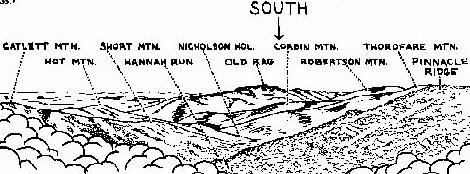
MILE 38.6, STONY MAN MOUNTAIN OVERLOOK. Hughes River Gap.
Elevation 3,100 feet. Water, toilets, A.T. access. (As you approach the
overlook from the south, the high point ahead is The Pinnacle. As you enter
the overlook at its north end, you look directly ahead to the profile of Stony
Man.) The view here is straight out to the town of Luray, in the Page Valley.
Beyond it, the low notch in the Massanutten on the far side of the valley is
New Market Gap. Because of the lights of Luray and other towns in the Valley,
this overlook is well worth a stop after dark.
This is a long overlook, in two parts, with a bulletin board near the
middle. The drinking fountain (turned off in winter) is on the wall at the
south end. A short trail goes from the south end of the overlook to the
toilets, and continues to the A.T. Distances on the A.T.: South (to the left)
it's 2.0 miles to the dining hall at Skyland. North (to the right) it's 1.2 miles
to the parking area at Mile 37.9 on the Drive.
Trivia: This is the second-longest overlook in the Park. Hogback
Overlook, Mile 20.8 to 21.0, is 75 feet longer.
MILE 39.1, PARKING AREA, west side. A.T. access, hikes. The A.T. is
less than fifty yards uphill from the parking area. Several hikes can be
started here, but I will recommend only one: Little Stony Man. (Hikes to
Stony Man summit and hikes on the Passamaquoddy trail are best started
from Mile 41.7.)
Geology: The hidden contact between the Pedlar and Catoctin
formations crosses the ridge a hundred feet north of the parking area. From
this point south, for about 25 miles, nearly all the rocks exposed beside the
Drive are greenstone—ancient lavas of the Catoctin formation. I'll mention
some of the exceptions when we get to them.
|
HIKE: Little Stony Man. Round trip 0.9 mile; total climb about 270 feet; time
required 1:00. Sheer cliffs, with good views. An easy hike, though part of the
trail is rather rough.
Go to the A.T. and turn left. The trail climbs steadily for a third of a mile,
then swings right and climbs to the ridge crest. There, at a concrete marker
post, a side trail on the left goes first to the upper cliff of Little Stony Man, and
then to Stony Man summit. Continue straight ahead, to the viewpoint on the
lower cliff of Little Stony Man.
Looking to the left from the viewpoint, you can see the higher cliffs of
Stony Man. With a little imagination you can make out the eye notch, nose,
mustache, and beard. The town of Luray is straight out in the Valley. To the
right you can see two stretches of Skyline Drive, with Stony Man Mountain
Overlook on the left of the more distant one. In the distance, a little to the right
of the overlook, is the sharp peak of Marys Rock; farther right, and a little
closer, is the Pinnacle.
Little Stony Man is a good place to watch the sunset, especially if you've
brought a flashlight, so you can stay a while after the sun is gone.
Geology: You're standing on top of the second Catoctin lava flow. The cliffs
that rise above you are lava of the third flow. When enough time elapsed
between eruptions, soil and sediments collected on top of the older lava.
That's what happened here. As the molten lava of the third eruption advanced
it churned up soil, sand, and mud. The rock that rises beside the trail here is
worth close study. The greenstone contains red-brown lumps of ancient mud
and soil, grains of sand, and some silvery schist that may have been formed
from a layer of volcanic ash that fell before the lava flow. (The rocks are also
dotted with white, green, and gray lichens.)
|
|