|
HIKE: Jones Run Falls. Round trip 3.6 miles; total climb about 915 feet;
time required 3:15. A not very difficult hike on a good trail to an attractive
waterfall. See map page 200.
Take the Jones Run Trail at the east end of the parking area. Cross the A.T.
and after about half a mile cross Jones Run. The trail follows an old road trace
for another third of a mile, then swings left and continues downhill through a
very young forest that was a pasture when the Park was created. After you
cross a shallow ditch that may have been a Civil War trench, and joining the
stream on your left, continue another 0.2 mile to the head of the falls. The trail
swings sharp right, then makes a switchback to the left and returns to the
base of the falls. Jones Run drops about 42 feet over a nearly vertical cliff that
crosses the gorge and continues for a distance down the left bank of the
stream, Where the cliff is watered by spray from the falls, it's covered with a
great variety of mosses and flowering plants.
|
MILE 84.3, A.T. CROSSING. Elevation 2,810 feet. Parking for several
cars in the grass on the west side. Distances on the A.T.: North (on the east
side of the Drive) it's 1.4 miles to Browns Gap, Mile 83.0. South (on the
west side) it's 1.1 miles to Blackrock and 2.3 miles to Blackrock Gap, Mile
87.4.
MILE 84.7, ABANDONED ROAD, east side. This is an exploring
possibility for experienced hikers. The entrance is grassy and hard to see;
look for the yellow posts and chain. I have not explored this area. Park
naturalists Bob Momich and Amanda Moody report as follows:
|
The trail passes signs of mountain people and the CCC: wells, rock walls,
and piles of decaying chestnut wood. About a mile from the Drive, the trail
divides. The right fork is obvious. Take the left fork, which is overgrown and
obscure. Where it turns sharp left at some rock walls, keep going straight
ahead. Cross a fence, leaving the Park. Enter an open field, with a good view of
Cedar Mountain a head and Via Hollow to the right. Less than 300 yards ahead
is the Via family cemetery. The dates on the stones are evidence of high infant
mortality among the mountain people. Via is the original (and present) name
of the family. Viar and Viare, which appear on some of the stones, are
variants.
|
MILE 84.8, BLACKROCK PARKING, west side. This is the closest
approach to Blackrock from the Drive. A hundred feet from Skyline Drive
is parking space for 12 cars. The entrance road is well marked.
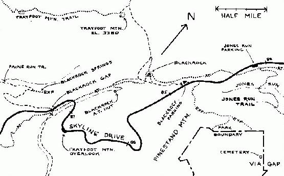 |
| Map of Blackrock Area |
|---|
|
HIKE: Blackrock Summit. Round trip 1.0 miles; total climb about 175 feet;
time required 1:10. An easy hike with outstanding views and a little geology.
See map below.
Beyond the chain the Trayfoot Mountain trail (a former fire road, which still
looks like a road) parallels the Drive for a short distance, then swings up to the
ridge top, where it touches the A.T. Step over onto the A.T., and continue in
the same direction. Walk a third of a mile on a good trail with a very easy climb,
through pleasant woods. Then the trail swings right, onto a talus slope. After
another hundred feet you're crossing a talus slope that goes down a tenth of a
mile to your right, made of rocks from breadbox size to Buick size. And, beyond
the slope, a wide-open breathtaking view across Madison Run and Dundo
Hollow. The trail makes a 200-yard loop around three sides of Blackrock
summit. In the middle of the loop, the Blackrock Spur trail goes off to the right.
The Blackrock Spur trail descends 0.2 mile to the Trayfoot Mountain trail,
which continues another 0.7 mile to Trayfoot Mountain summit, where you'll
find the foundation of a former fire tower. (There are no views from the
summit.) The Trayfoot Mountain trail continues another 3.9 miles to the Paine
Run trail.
There's no trail to the top of Blackrock. The climb is a rock scramble that
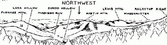
you can begin at any point on the loop. On the summit, the view is wrapped
around you for more than 300 degrees. Looking away from the woods, the
high peak in front of you is Trayfoot Mountain, just over half a mile away. (Its
elevation is about 3,380 feet; you're at 3,092.) Trayfoot Mountain extends far
to the left from its highest point, then descends into Paine Run hollow. The
low, free-standing mountain beyond its foot is Horsehead. Buzzard Rock rises
to the left of the mouth of the hollow, the far edge of which is formed by Rocks
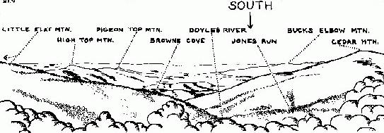
Mountain.
To the right of Trayfoot summit, Furnace Mountain rises at the mouth of
Madison Run hollow. (Madison Run was named for a wealthy settler who,
about 1750, built an estate called Madison Hall near its mouth. Furnace
Mountain gets its name from Mount Vernon Furnace, which was built at its
>
foot in 1848 for the reduction of iron ore.) Farther right are Austin Mountain,
Lewis Mountain, and Lewis Peak. The long Rockytop ridge forms the far
boundary of the hollow, and joins the main Blue Ridge toward the right, where
you see a roadcut beside the Drive. Farther right on a very clear day you can
see Hightop, thirteen miles away. Still farther right, and much closer, is Big
Flat Mountain—the site of the Loft Mountain Campground.
Legend: In the spring of 1781, during the American Revolution, the British
were pressing westward in Virginia. The Virginia Assembly, to avoid capture,
fled across the mountain to Staunton. Thomas Jefferson, governor of
Virginia, entrusted the State Archives and Great Seal to his friend Bernis
Brown. Bernis hid them in a cave here at Blackrock, where they remained
throughout the rest of the war.
Geology: Blackrock summit and the talus slopes below it are Hampton
quartzite. Maybe you can imagine the great monolith that all this started from.
When it was exposed by erosion it had already been cracked and weakened
by pressure, and by cycles of heating and cooling. Rain water seeped into the
cracks and froze, and melted and seeped and froze again. In a very short time,
as geologists measure—probably less than 100,000 years—Blackrock
crumbled into the magnificent but messy pile you're standing on.
In a fresh break, the quartzite is medium salt-and-pepper gray. Weathering
has stained its surface pale purplish gray-brown, tan, and red-brown. Many of
the rocks are covered with close-clinging pale green lichen. (A photographer
with a closeup lens, color film, and a taste for abstract art, could spend some
time here.) Any blackness that Blackrock may have is due to its burden of rock
tripe—a coarse lichen that's dark brown and crispy when it's dry, and gray-
green and leathery when it's wet.
Oral history: I have reports from oldtimers who visited the Blackrock
Springs Hotel (which was about a mile down the hollow on the Paine Run
side) during the early years of this century. The trip up to Blackrock was a
favorite excursion for hotel guests. And one of its outstanding attractions—at
least the thing the oldtimers remember most vividly—was the chance to
scratch ones name or initials on the rocks. Which consisted, I gather, of
scratching off the rock tripe.
|
MILE 86.8, TRAYFOOT MOUNTAIN OVERLOOK. Drinking fountain
(turned off in winter). Elevation 2,530 feet. The short hollow in front of the
overlook drains into the north branch of Moormans River in Via Hollow, at
the foot of Pasture Fence Mountain (which has grassy clearings near its
top.) To the right of Pasture Fence and more distant, with clearings and
radio towers on top, is Bucks Elbow Mountain. From the south end of the
overlook on a very clear day you can see far to the right, across the Blue
Ridge to the Allegheny Mountains on the far side of the valley.
MILE 87.4, BLACKROCK GAP. Elevation 2,320 feet. Parking on west
side. Fire road; trail head. A.T. access. The A.T. comes to the edge of the
Drive on the east side, but does not cross it. Distances on the A.T.: North
(to the left) it's a quarter of a mile to the Drive crossing at Mile 87.2. South
(to the right) it's 1.8 miles to the Drive Crossing at Mile 88.9.
On the west side of the Drive the Paine Run trail goes 3.8 miles to the Park
boundary, where it joins Virginia secondary roads Nos. 614 and 661. On the
east side the fire road goes 1.1 miles to the Park boundary, then continues for
0.4 mile to the north fork of Moormans River in Via Hollow, which was a
popular Catch and Release stream prior to the flood of 1995.
In June of 1995 unusually intense rains caused localized flooding and
triggered numerous landslides which dramatically altered the landscape along
the north fork of Moormans River. The lower 3 miles of this area is open for
day-use only. The flood washed away several sections of the fire road which
the park has no plans to rebuild. Hikers to this area should be prepared to
bushwhack and be alert for hazards along what remains of the old road bed.
Paine Run hollow is big and wild—a great place for exploring and
backcountry camping. Although you can reach it from the bottom, you have
to cross private land to do so. It might be better to start from Blackrock Gap
and walk down the trail.
History: About a mile down the Paine Run trail is Blackrock Springs,
which at the turn of the century was a fashionable resort with a hotel,
cabins, recreation hall, and bowling alley. The resort reached the height of
its popularity in the 1840's and 1850's. It burned down, probably as a result
of arson, early in this century. The waters of Blackrock Springs were said to
be good for whatever ails you. According to advertisements they contained
iron, soda, lime, magnesia, and carbonic acid gas. When Mme. Curie discovered
radium, that too was added to the list of ingredients. There were
seven springs of different colors and different healing properties, including
one for rheumatism, one for arthritis, one for gout, and one for aiding the
growth of hair. People still come to Blackrock Gap and carry jugs down the
trail to bring back some of the healing water. If you'd like to see where the
hotel once stood, or if you're suffering from shortage of hair or other
ailment, try this:
|
HIKE: Blackrock Springs. Round trip 2.2 miles; total climb about 425 feet;
time required 2:10. (See map, page 208.) Follow the Paine Run trail downhill
on the west side of the Drive, past a switchback to the right, to a sharp
switchback to the left. Leave the trail at that point and follow an old road trace
straight ahead. In the next few hundred yards you will see level areas where
cabins once stood, uphill to the right. Pass a covered spring at the right-hand
edge of the road trace. (I don't know which of the seven ailments this one is
good for.) The sites of various hotel buildings are straight ahead, as well as
ahead and to the left. Explore at will.
|
|