|
HIKE: Jarman Gap. Circuit 0.5 mile; total climb about 135 feet; time
required 0:25. A pleasant, easy hike through the woods.
Take the left-hand fire road, which curves right and descends rather
steeply to a stand of tall tulip poplars. The bank on the right is rich in ferns:
Christmas ferns, ebony spleenwort, polypody, and rattlesnake fern. (There's
some poison ivy, too.) At the A.T. junction, 250 yards from the start, turn right,
uphill, through a grove of big trees—up to three feet in diameter—some of
them oaks but mostly tulip poplars. Where the trail turns sharp right, there's a
pretty little spring on the left, which may be dry in summer. (Don't drink the
water without boiling it.)
Continue to the second fire road, a quarter of a mile from the first one. The
A.T. continues on the other side of the road. Turn right. It's only a hundred
yards more to your starting point.
|
|
HIKE: Beagle Gap. One way 2.7 miles; total climb about 825 feet;
time required 2:25. This is a fairly easy hike across the semi-open crest of Calf
Mountain, with views from the cleared pasture land. It's a one-way hike,
which requires that you leave a car in Beagle Gap, Mile 99.5, or have
someone meet you there.
On the east side of the Drive take the right-hand fire road, which goes
uphill 200 yards to the A.T. Turn right onto the A.T. and, after a few tenths of a
mile, pass under the power line (see below). About a mile from the start of
your hike, pass the Calf Mountain A.T. Hut and spring. Continue to the summit
of Calf Mountain (elevation 2,975 feet), 1.7 miles from Jarman Gap. From a
point a few feet short of the summit, look back the way you came for a fine
view of Bucks Elbow Mountain (with radio towers on top) and, farther left, the
Moorman River valley.
The trail continues along the ridge crest, with white blazes painted on the
rocks. It passes to the left of the second summit of Calf Mountain, and
descends to the Drive in Beagle Gap.
|
MILE 97.4, POWER LINE CROSSING. Heavy, multiple wires, on big steel
towers. There's parking space in the grass on the west side of the Drive.
Under the wires is a bank about ten feet high, which is sometimes clear and
sometimes overgrown. When it's clear there's a striking view from the top,
down a cleared swath many miles long. A double line of steel towers, strung
together by long catenaries of wire, marches down over the ridges and into
the hollow of Sawmill Run, out through the mouth of the hollow, past
Ramsey Mountain on the left and the foot of Sawmill Ridge on the right, into
the Valley. Under some atmospheric conditions the wires make a sizzling
sound, like something frying over a low fire, and it seems to come from all
around you.
MILE 97.6, GEOLOGY. There's parking in the grass on the west side of
the Drive. In the roadcut on the east side is an exposure of sedimentary
rocks (laid down in the interval between two ancient lava flows) of the
Catoctin formation: coarse sandstone with some small quartz pebbles, and
some soft, crumbly phyllite. A good part of the rock surface is covered with
poison ivy.
MILE 98.9, CALF MOUNTAIN OVERLOOK. Elevation 2,480 feet. As you
approach the overlook the road appears to go right out into the sky. This is
a long overlook with a 300-degree wrap-around view. To see all of it you
should park your car and walk from one end of the overlook to the other.
 |
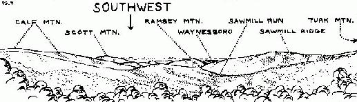
| View from Calf Mountain Overlook (No. 1) |
|---|
The overlook has been cut out, so both the sketches on this page are good
for years to come. From the south end of the overlook you can see a smoky
smokestack in Waynesboro. Farther right, on a more distant ridge, Interstate
64 descends into the valley. Calf Mountain rises up behind the overlook.
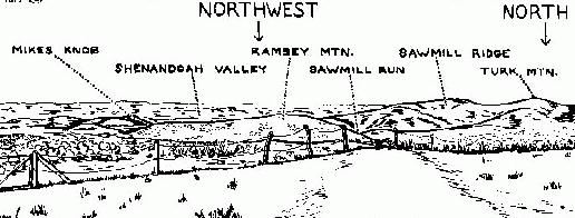 |
| View from Calf Mountain Overlook (No. 2) |
|---|
MILE 99.5, BEAGLE GAP. Elevation 2,530 feet. A.T. crossing. Hikes. Parking
is on the east side of the Drive. The Drive passes between Bear Den Mountain
on the west side and Calf Mountain on the east. The fence on each side of the
Drive is at the Park boundary. The A.T. crosses the Drive here.
Distances on the A.T.: North (on the east side of the Drive) it's 2.7 miles to
Jarman Gap, Mile 96.8 South (on the west side) it's 1.8 miles to McCormick
Gap, Mile 102.1.
|
HIKE: Calf Mountain Summit. Round trip 2.1 miles; total climb about 495
feet; time required 1:45. An easy hike through partly open former pasture.
Take the A.T. on the east side of the Drive. It ascends along the right flank of
the first crest, and continues along the semi-open saddle, where it's marked
by white blazes on the rocks. The high point of the trail, on the second crest of
Calf Mountain (elevation 2,975 feet) is your destination. From there you have
a fine view straight ahead of the summit of Bucks Elbow Mountain, with the
radio installations on top. If you follow the trail a few yards more, you can see
farther to the left, with a view of the whole length of the Moorman River
valley.
|
|
HIKE: Bear Den Mountain. Round trip 1.2 miles; total climb about 355 feet;
time required 1:05. Take the A.T. on the west side of the Drive, and climb
through mostly open fields to the summit (elevation 2,885 feet). The towers
serve numerous communication systems. There are views on both sides of
the ridge.
|
MILE 99.8, BEAGLE GAP OVERLOOK. Elevation 2,495 feet. There's a
narrow view down Greenwood Hollow into the Piedmont. The divided
highway you see is Interstate 64, headed for Charlottesville. Note that
there's a fence here, about 50 feet from the edge of the pavement.
Everything beyond it is private property.
MILE 101.2, PRIVATE ROAD, west side. This road goes half a mile to the
Police Radio Station on the summit of Bear Den Mountain.
MILE 102.1, McCORMICK GAP. Elevation 2,440 feet. A.T. crossing.
There is limited parking on the east side of the Drive. Distances on the A.T.:
North (on the west side of the Drive) it's 1.8 miles to Beagle Gap, Mile 99.5.
South (on the east side) it's 3.0 miles to Skyline Drive at Mile 105.2 near
Rockfish Gap. From McCormick Gap to Rockfish Gap, the A.T. lies on an
easement over private land. If you're going south on the A.T., it's best to
stay on or near the trail.
MILE 102.4, MCCORMICK GAP OVERLOOK. Elevation 2,455 feet. If the
overlook has been recently cleared you have a good view of the Shenandoah
Valley, with the city of Waynesboro toward the left. To your right is
Bear Den Mountain, with the Virginia Police radio installation on top.
Lower, farther left, is the grassy clearing in Beagle Gap; still farther left is
Calf Mountain, with Calf Mountain Overlook on its left flank. Continuing to
the left, you have a view straight up the hollow of Sawmill Run, with the
main Blue Ridge on its right. On the left side of the hollow, Sawmill Ridge
runs up to Turk Mountain.
MILE 104.6, ROCKFISH GAP ENTRANCE STATION. Elevation 2,070
feet. You can get information here, and help if you need it. The station may
be unmanned at night and in the winter.
MILE 105.1, PARK BOUNDARY. South of this point you're on the Blue
Ridge Parkway.
MILE 105.2, APPALACHIAN TRAIL. Elevation 1,900 feet. The A.T. goes
steeply up the bank on the east side. To the north (on the east side) it's 3.0
miles to McCormick Gap, Mile 102.1 .To the south the A.T. follows the road,
crossing Interstate 64 and U.S. 250 on the overpasses.
MILE 105.4, ROCKFISH GAP. Elevation 1,900 feet. Interstate 64 and
U.S. 250 interchange. The Blue Ridge Parkway continues to the south from
here. South of the overpasses and just west of the Parkway are motels,
restaurants, and a gas station. Waynesboro, west on U.S. 250 at the foot of
the mountain, offers food, lodging, and a hospital.
There is a tourist information center in Rockfish Gap. It's open during the
summer travel season, and has information on food, lodging, and tourist
attractions in the area. To find it, if you're going south: cross both
overpasses and turn right. Look for a large sign beside the road that says
"Rockfish Gap Regional Visitor Center." An arrow points to the Center, on
the lower level of one of the motel buildings.
History: At first only a buffalo path crossed the mountain here. Later a
dirt road was built to carry produce from the Shenandoah Valley to the head
of navigation on the Rockfish River. It joined the Three Notched Road
(which crossed the mountain in Jarman Gap) near the town of Wayland
Crossing. The Blue Ridge Tunnel runs under Rockfish Gap, just outside the
Park, and takes the C & O Railroad through the mountain about 500 feet
below the surface. The tunnel was engineered by Colonel Claude Crozet,
who had crossed the Alps with Napoleon. In 1870 the town of Wayland
Crossing was renamed Crozet in his honor. Crozet is visible from the Drive:
going north, as you round the curve at Mile 100.4, Crozet is the town at the
foot of the mountain, ahead and to the right.
Rockfish Gap was the site of Mountain Top Tavern, one of the most
famous taverns in the state. Many important conferences were held here.
In 1818 a convention of 28 prominent citizens of Virginia, including Chief
Justice Marshall and ex-presidents Madison, Monroe, and Jefferson, met
here at Mountain Top Tavern to decide whether the University of Virginia
should be in Staunton, Lexington, or Charlottesville.
|